Staff Sgt. Derek Howard, 816th Expeditionary Airlift Squadron, watches cargo bundles delivered by the Joint Precision Air Drop System (JPADS) to a drop zone in Afghanistan.
Credit: U.S. Air Force

Military Applications

Time and positioning go beyond navigation.

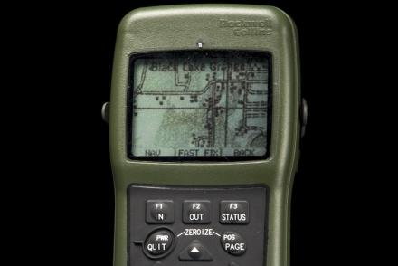
GPS has become an indispensible military asset and transformed space into a platform for war. Public awareness of GPS grew during the 1990–91 Persian Gulf War, which showcased its effectiveness to synchronize operations, provide navigation information, pinpoint targets, and locate personnel.

GPS now is the core navigation system for U.S. military aircraft, vessels, vehicles, and personnel. It has changed the nature of weapons targeting, command and control, guidance of unmanned systems, and supply delivery on the battlefield.

The handheld Precision Lightweight GPS Receiver (PLGR), popularly known as the “Plugger,” replaced the Manpack in 1993. These units were similar to civilian receivers of the time but used higher-precision GPS signals.
Beginning in 2004, Rockwell Collins made a smaller handheld military GPS receiver. The Defense Advanced GPS Receiver (DAGR), pronounced “dagger,” integrates a map graphic with two channels of GPS signals coded specifically for the military and map graphics. Predecessor receivers showed only words and numbers.
This autonomous air vehicle uses GPS and inertial navigation for observation missions in hazardous situations without exposing its operator to risk. RQ-16s provided the first detailed interior imagery of damaged nuclear reactors in Japan during 2011 and have flown with police SWAT teams and military bomb disposal units.
Aircraft dropping supplies by parachute have to fly at dangerously low altitudes. Material can miss the intended target and fall into enemy hands. This GPS guidance unit and parafoil steer cargo dropped from higher altitudes to a pre-programmed landing zone with improved accuracy.
The uniform displayed here was worn by Sgt. Joseph Guenther, who, as a U.S. Army forward observer during two tours in Afghanistan, used a DAGR to direct artillery fire to targets.
The Manpack was one of the first portable GPS receivers for combat troops. It weighs about 8 kilograms (17 pounds). About 1,400 were manufactured from 1988 to 1993 and were used by coalition ground troops in Operation Desert Storm in 1991. GPS allowed quick and precise navigation in the featureless desert and provided a tactical advantage against an enemy with no access to GPS technology.