Smithsonian
  • Navigating
    at Sea
    • Challenges of Sea Navigation
    • Navigating Without a Clock
    • The Longitude Problem
    • The U.S. Goes to Sea
    • Navigate at Sea! Activity
  • Navigating
    in the Air
    • Challenges of Air Navigation
    • Early Air Navigators
    • Navigation at War
    • Navigate the Skies! Activity
  • Navigating
    in Space
    • Challenges of Space Navigation
    • Reaching for the Moon
    • Navigating in Deep Space
    • Navigate in Space! Activity
  • Satellite Navigation
    • Challenges of Satellite Navigation
    • Reliable Global Navigation
    • Global Positioning System (GPS)
    • Who Uses Satellite Navigation
  • Navigation
    for Everyone
    • Meet a Professional Navigator
    • Personal Navigation Stories
  • Timeline of Innovation
  • Artifacts
  • Learning Resources
  • Multimedia Gallery
  • Research
  • Visit the Exhibition

Search form

Time and Navigation Home
Facebook Twitter YouTube Pinterest
Time and Navigation
The untold story of getting from here to there.
Home

Search form

  • Navigating at Sea
  • Navigating in the Air
  • Navigating in Space
  • Satellite Navigation
  • Navigation for Everyone
  • Timeline of Innovation
  • Artifacts
  • Learning Resources
  • Multimedia Gallery
  • Research Journal
  • Visit the Exhibition
  • Meet a Professional Navigator
  • Personal Navigation Stories
Meet The Navigator

John F. Sullivan

Deputy Chief
Worcester, Massachusetts

Navigating Through Smoke and Fire

"In 1999, we responded to a fire in a vacant warehouse. Two of our colleagues became lost while searching through the smoke-filled structure for two homeless people reportedly inside. We sent in several teams of firefighters to try and locate them and lead them to safety. Before they could get out, the structure collapsed, killing the lost team and four of their would-be rescuers."

Why do you need better positioning, navigation, and timing technology?

"When firefighters enter a burning structure, especially large complex commercial buildings, they can quickly lose visibility and their ability to maintain orientation. And traditional GPS doesn’t work inside buildings."

How are firefighters normally tracked indoors?

"The fire chief keeps track of the crew’s positions by following radio calls and drawing a sketch on an "accountability board"—but it’s all too easy for critical information to be missed or misinterpreted."

How is this technology changing your life?

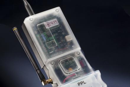
"We are getting close to a reliable and affordable solution that uses technologies such as inertial navigation and others to provide real-time positional data of our firefighters. Knowing where your teams are at all times can be critical when things go wrong."

The Challenge of Indoor Navigation

Emergency personnel cannot receive GPS signals indoors. New navigation systems combining radio signals with inertial navigation are now in testing. Cell phone companies, retailers, and other organizations are also exploring the possibilities of indoor navigation technology.
Worcester Polytechnic Institute


wpi312018.jpeg

Deputy Chief of the Worchester Fire Department John F. Sullivan
“When firefighters enter a burning structure, especially large complex commercial buildings, they can quickly lose visibility and their ability to maintain orientation. And traditional GPS doesn’t work inside buildings."
Credit: Worcester Polytechnic Institute (WPI)

wpi312018.jpeg

test
“When firefighters enter a burning structure, especially large complex commercial buildings, they can quickly lose visibility and their ability to maintain orientation. And traditional GPS doesn’t work inside buildings."
Credit: Worcester Polytechnic Institute (WPI)

incident_commander_console.jpeg

A Future Concept for a Firefighter Locator System
This graphic shows how personal radiometric and inertial navigation devices could allow incident commanders to keep track of firefighters within a burning building.
Credit: Worcester Polytechnic Institute (WPI)

610-wpi_locator_system.jpeg

A Screen for a Future Incident Commander Console
This graphic shows how personal radiometric and inertial navigation devices could allow incident commanders to keep track of firefighters within a burning building.
Credit: Worcester Polytechnic Institute (WPI)

nasm2012-02146.jpg

WPI Precision Personnel Locator (PPL)
A prototype navigation unit to for emergency response personnel.
Credit: National Air and Space Museum, Smithsonian Institution
previous pauseresume next

Help inspire the next generation.

Join us on Twitter and share your#timenav story.

  • Navigating at Sea
    • Challenges of Sea Navigation
    • Navigating Without a Clock
    • The Longitude Problem
    • The U.S. Goes to Sea
    • Navigate at Sea! Activity
  • Navigating in the Air
    • Challenges of Air Navigation
    • Early Air Navigators
    • Navigation at War
    • Navigate the Skies! Activity
  • Navigating in Space
    • Challenges of Space Navigation
    • Reaching for the Moon
    • Navigating in Deep Space
    • Navigate in Space! Activity
  • Satellite Navigation
    • Challenges of Satellite Navigation
    • Reliable Global Navigation
    • Global Positioning System (GPS)
    • Who Uses Satellite Navigation
  • Navigation for Everyone
    • Meet a Professional Navigator
    • Personal Navigation Stories
  • Timeline of Innovation
  • Artifacts
  • Learning Resources
  • Multimedia Gallery
  • Research
  • Visit the Exhibition
  • Terms of Use
  • Privacy
  • Contact
  • Sponsors
  • Press
  • Donate
Smithsonian Logo National Air and Space Museum Home National Air and Space Museum Home National Museum of American History Home
Smithsonian
Home Facebook Twitter Google Plus Pinterest YouTube

This exhibition is a collaboration between the National Air and Space Museum and the National Museum of American History.

Sponsors | Contact | Terms of Use | Privacy