Smithsonian
  • Navigating
    at Sea
    • Challenges of Sea Navigation
    • Navigating Without a Clock
    • The Longitude Problem
    • The U.S. Goes to Sea
    • Navigate at Sea! Activity
  • Navigating
    in the Air
    • Challenges of Air Navigation
    • Early Air Navigators
    • Navigation at War
    • Navigate the Skies! Activity
  • Navigating
    in Space
    • Challenges of Space Navigation
    • Reaching for the Moon
    • Navigating in Deep Space
    • Navigate in Space! Activity
  • Satellite Navigation
    • Challenges of Satellite Navigation
    • Reliable Global Navigation
    • Global Positioning System (GPS)
    • Who Uses Satellite Navigation
  • Navigation
    for Everyone
    • Meet a Professional Navigator
    • Personal Navigation Stories
  • Timeline of Innovation
  • Artifacts
  • Learning Resources
  • Multimedia Gallery
  • Research
  • Visit the Exhibition

Search form

Time and Navigation Home
Facebook Twitter YouTube Pinterest
Time and Navigation
The untold story of getting from here to there.
Home

Search form

  • Navigating at Sea
  • Navigating in the Air
  • Navigating in Space
  • Satellite Navigation
  • Navigation for Everyone
  • Timeline of Innovation
  • Artifacts
  • Learning Resources
  • Multimedia Gallery
  • Research Journal
  • Visit the Exhibition
  • Challenges of Satellite Navigation
    • Navigation Gone Wrong: Soviets Shoot Down an Airliner
  • Reliable Global Navigation
    • Inertial Navigation
      • Charles Stark Draper
      • Developing Inertial Navigation
    • The First Satellite Navigation System
      • Transit Satellites
      • Navigating a Submarine
    • Improving Satellite Navigation
      • Clocks in Space
      • Evolving Solutions
  • Global Positioning System (GPS)
    • GPS Begins
    • The Satellite Constellation
    • Synchronized Accurate Time
    • Risks to the System
    • International Systems
  • Who Uses Satellite Navigation
    • Military Applications
    • Civilian Applications
      • The Commercial Market
      • Improving Accuracy
      • Looking Ahead

Explore More

Model of Ship’s Inertial Navigation (SINS) Stable Platform  »
A Future Concept for a Firefighter Locator System »
Magellan PathMaster Navigation Information System »
Emergency Vehicle Location System »
System Maintenance »

Global Positioning System (GPS)

In 1973, the Defense Department combined its competing satellite navigation systems.

The new joint program under the Air Force was called the NAVSTAR Global Positioning System, or GPS. It introduced synchronized time from space, provided by onboard atomic clocks. The system was intended for a range of military applications, including locating ships and targeting weapons. GPS designers envisioned that civilians would use the system as well.

constellation_3.jpg

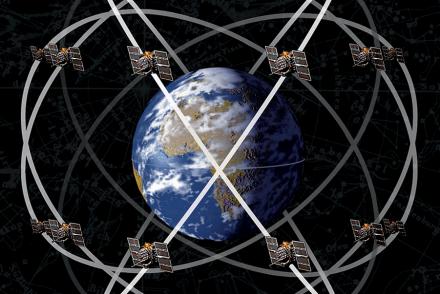
GPS Constellation
GPS satellites are positioned in precise, circular orbits 18,000 kilometers (11,000 miles) above the Earth. They orbit once every 12 hours.
Credit: National Air and Space Museum, Smithsonian Institution.

532-060104-f-3966r-005.jpg

U.S. Naval Observatory Alternate Master Clock
The U.S. Naval Observatory Alternate Master Clock at Schriever Air Force Base.
Credit: U.S. Air Force

624-070913-f-2661b-203_-_tech._sgt._dana_ammend_uploads_navigation_and_timing_data_sept._13_to_global_positioning_system.jpg

System Maintenance
The successful operation of a satellite navigation system requires around-the-clock monitoring of the satellites’ health and the periodic replacement of older satellites.
Credit: U.S. Air Force

500-si_hiw_gps_fa_la2534dc.jpg

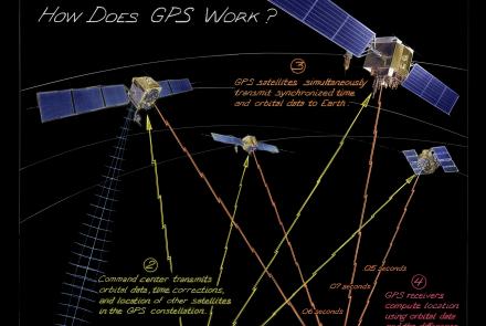
How Does GPS Work?
From maintaining infrastructure, transporting goods, delivering services, or just meeting friends, people often use technology just as sophisticated as that used by pilots and soldiers. How does it work?
Credit: National Air and Space Museum, Smithsonian Institution.
previous pauseresume next
  • GPS Begins »

    Developing GPS components began in 1973, when the Joint Program Office was established under the Air Force.

  • The Satellite Constellation »

    In 1974, Rockwell International (now a division of Boeing) was contracted to build GPS satellites.

  • Synchronized Accurate Time »

    GPS requires precise clocks to provide astounding positional accuracy.

  • Risks to the System »

    Satellites provide essential navigation services, but threats exist to their operation.

  • International Systems »

    The GPS system operated by the United States is not the only satellite navigation system.

  • Navigating at Sea
    • Challenges of Sea Navigation
    • Navigating Without a Clock
    • The Longitude Problem
    • The U.S. Goes to Sea
    • Navigate at Sea! Activity
  • Navigating in the Air
    • Challenges of Air Navigation
    • Early Air Navigators
    • Navigation at War
    • Navigate the Skies! Activity
  • Navigating in Space
    • Challenges of Space Navigation
    • Reaching for the Moon
    • Navigating in Deep Space
    • Navigate in Space! Activity
  • Satellite Navigation
    • Challenges of Satellite Navigation
    • Reliable Global Navigation
    • Global Positioning System (GPS)
    • Who Uses Satellite Navigation
  • Navigation for Everyone
    • Meet a Professional Navigator
    • Personal Navigation Stories
  • Timeline of Innovation
  • Artifacts
  • Learning Resources
  • Multimedia Gallery
  • Research
  • Visit the Exhibition
  • Terms of Use
  • Privacy
  • Contact
  • Sponsors
  • Press
  • Donate
Smithsonian Logo National Air and Space Museum Home National Air and Space Museum Home National Museum of American History Home
Smithsonian
Home Facebook Twitter Google Plus Pinterest YouTube

This exhibition is a collaboration between the National Air and Space Museum and the National Museum of American History.

Sponsors | Contact | Terms of Use | Privacy