Smithsonian
  • Navigating
    at Sea
    • Challenges of Sea Navigation
    • Navigating Without a Clock
    • The Longitude Problem
    • The U.S. Goes to Sea
    • Navigate at Sea! Activity
  • Navigating
    in the Air
    • Challenges of Air Navigation
    • Early Air Navigators
    • Navigation at War
    • Navigate the Skies! Activity
  • Navigating
    in Space
    • Challenges of Space Navigation
    • Reaching for the Moon
    • Navigating in Deep Space
    • Navigate in Space! Activity
  • Satellite Navigation
    • Challenges of Satellite Navigation
    • Reliable Global Navigation
    • Global Positioning System (GPS)
    • Who Uses Satellite Navigation
  • Navigation
    for Everyone
    • Meet a Professional Navigator
    • Personal Navigation Stories
  • Timeline of Innovation
  • Artifacts
  • Learning Resources
  • Multimedia Gallery
  • Research
  • Visit the Exhibition

Search form

Time and Navigation Home
Facebook Twitter YouTube Pinterest
Time and Navigation
The untold story of getting from here to there.
Home

Search form

  • Navigating at Sea
  • Navigating in the Air
  • Navigating in Space
  • Satellite Navigation
  • Navigation for Everyone
  • Timeline of Innovation
  • Artifacts
  • Learning Resources
  • Multimedia Gallery
  • Research Journal
  • Visit the Exhibition
  • Challenges of Satellite Navigation
    • Navigation Gone Wrong: Soviets Shoot Down an Airliner
  • Reliable Global Navigation
    • Inertial Navigation
      • Charles Stark Draper
      • Developing Inertial Navigation
    • The First Satellite Navigation System
      • Transit Satellites
      • Navigating a Submarine
    • Improving Satellite Navigation
      • Clocks in Space
      • Evolving Solutions
  • Global Positioning System (GPS)
    • GPS Begins
    • The Satellite Constellation
    • Synchronized Accurate Time
    • Risks to the System
    • International Systems
  • Who Uses Satellite Navigation
    • Military Applications
    • Civilian Applications
      • The Commercial Market
      • Improving Accuracy
      • Looking Ahead

Explore More

Schriever Air Force Base Ground Station Control Room »
Latitude and Longitude »
Seiko Epson Digital Assistant, 1997 »
Quartz Resonator for Transit Satellites »
Lockheed SR-71 Blackbird on Display »

Inertial Navigation

An Inertial Navigation System (INS) uses motion and rotation sensors along with a computer to figure out the position, orientation, and speed of movement of a vehicle without using the stars, Sun, Moon, or other outside visual references. Traditionally, this was done with mechanical gyroscopes and accelerometers. 

A key consideration in inertial navigation systems is that even the most accurate units "drift" over time, thus requiring additional periodic navigation fixes. Because of this, INS units are connected closely with other navigational systems, ranging from star trackers for celestial navigation (as was used on the Lockheed SR-71 Blackbird) to GPS, or even signals for  cellphone networks and wireless access points.

  • Charles Stark Draper »

    Helped advanced the art of inertial navigation.

  • Developing Inertial Navigation »

    Inertial navigation emerged nearly simultaneously out of several different programs in the United States and Great Britain.

nasm2013-00438.jpg

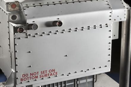
Nortronics NAS-14V2 Astroinertial Navigation System
The Astroinertial Navigation System provided rapid celestial navigation fixes for the SR-71.
Credit: National Air and Space Museum, Smithsonian Institution.

321-nasm-9a08308q.jpg

Lockheed SR-71 Blackbird on Display
The Astroinertial Navigation System helped this SR-71 Blackbird's crew set a coast-to-coast speed record of only 68 minutes.
Credit: National Air and Space Museum, Smithsonian Institution.
previous pauseresume next
  • Navigating at Sea
    • Challenges of Sea Navigation
    • Navigating Without a Clock
    • The Longitude Problem
    • The U.S. Goes to Sea
    • Navigate at Sea! Activity
  • Navigating in the Air
    • Challenges of Air Navigation
    • Early Air Navigators
    • Navigation at War
    • Navigate the Skies! Activity
  • Navigating in Space
    • Challenges of Space Navigation
    • Reaching for the Moon
    • Navigating in Deep Space
    • Navigate in Space! Activity
  • Satellite Navigation
    • Challenges of Satellite Navigation
    • Reliable Global Navigation
    • Global Positioning System (GPS)
    • Who Uses Satellite Navigation
  • Navigation for Everyone
    • Meet a Professional Navigator
    • Personal Navigation Stories
  • Timeline of Innovation
  • Artifacts
  • Learning Resources
  • Multimedia Gallery
  • Research
  • Visit the Exhibition
  • Terms of Use
  • Privacy
  • Contact
  • Sponsors
  • Press
  • Donate
Smithsonian Logo National Air and Space Museum Home National Air and Space Museum Home National Museum of American History Home
Smithsonian
Home Facebook Twitter Google Plus Pinterest YouTube

This exhibition is a collaboration between the National Air and Space Museum and the National Museum of American History.

Sponsors | Contact | Terms of Use | Privacy