Smithsonian
  • Navigating
    at Sea
    • Challenges of Sea Navigation
    • Navigating Without a Clock
    • The Longitude Problem
    • The U.S. Goes to Sea
    • Navigate at Sea! Activity
  • Navigating
    in the Air
    • Challenges of Air Navigation
    • Early Air Navigators
    • Navigation at War
    • Navigate the Skies! Activity
  • Navigating
    in Space
    • Challenges of Space Navigation
    • Reaching for the Moon
    • Navigating in Deep Space
    • Navigate in Space! Activity
  • Satellite Navigation
    • Challenges of Satellite Navigation
    • Reliable Global Navigation
    • Global Positioning System (GPS)
    • Who Uses Satellite Navigation
  • Navigation
    for Everyone
    • Meet a Professional Navigator
    • Personal Navigation Stories
  • Timeline of Innovation
  • Artifacts
  • Learning Resources
  • Multimedia Gallery
  • Research
  • Visit the Exhibition

Search form

Time and Navigation Home
Facebook Twitter YouTube Pinterest
Time and Navigation
The untold story of getting from here to there.
Home

Search form

  • Navigating at Sea
  • Navigating in the Air
  • Navigating in Space
  • Satellite Navigation
  • Navigation for Everyone
  • Timeline of Innovation
  • Artifacts
  • Learning Resources
  • Multimedia Gallery
  • Research Journal
  • Visit the Exhibition
  • Challenges of Sea Navigation
    • Navigation Gone Wrong: A British Fleet is Lost at Sea
    • Navigate at Sea! Activity
  • Navigating Without a Clock
    • Early Voyages
    • Dead Reckoning
    • Celestial Navigation
  • The Longitude Problem
    • Cash for Creativity
    • Early Sea Clock Experiments
    • Innovations in England
    • Innovations in France
    • The Chronometer
    • Observing the Skies
    • Navigation Gone Wrong: Wreck of the Arniston
  • The U.S. Goes to Sea
    • Early Contributions
      • Meet the Clockmaker: William Cranch Bond
      • Meet the Navigator: Eleanor Creesy
    • Wilkes Expedition
      • Meet the Mapmaker: Charles Wilkes
      • Maps and Charts
      • The "Scientifics"
  • Navigate at Sea! Activity

Explore More

Latitude »
Parrots »
Bats »
Using an Horary Quadrant »
Compass Rose »

Navigating Without a Clock

Mariners achieved remarkable feats of exploration using only the simplest tools.

Before accurate ship clocks were common, European navigators paid careful attention to time derived from the Sun, Moon, and stars. Aware of the risks, seafarers relied on their tools, know-how, and sometimes even luck when they ventured out on the world’s uncharted, dangerous oceans.

Early mariners made efforts to chart distant shorelines and ocean features even without first-hand knowledge. Europe’s first sea charts were simple outlines of coastlines made to supplement written or oral directions. They later evolved into more accurate navigation aids based on astronomy and mathematics.

212-038756.jpg

Frontispiece, The Mariners Mirrour, 1588
This illustration is the frontispiece to The Mariner’s Mirrour, one of the most famous collections of sea charts from the 16th century.
Credit: By Permission of the Folger Shakespeare Library

212-sil33-178-097.jpg

"Kalaniopuu, King of Hawaii, bringing presents to Captain Cook"
Over thousands of years, Polynesians migrated across vast distances and spread their culture across the Pacific.
Credit: Smithsonian Institution Libraries

212-champlain_map_of_the_northeast_coast_of_north_america_1607_from_the_library_of_congress_-_g3321.p5_1607_.c4_vault_-_vellum_15.jpg

Chart showing Nova Scotia to Cape Cod
This chart showing Nova Scotia to Cape Cod, based on Samuel de Champlain’s observations, was published in 1607.
Credit: Library of Congress, Geography and Map Division

212-1027151-portolan-chart-by-jorge-aguiar-dl-1027151.jpg

Compass Rose
Compass rose on a chart of the Mediterranean, 1492.
Credit: Yale Collection of American Literature, Beinecke Rare Book and Manuscript Library

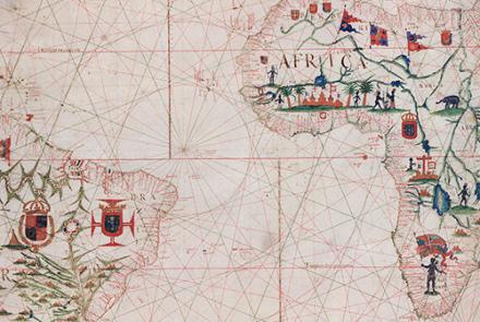
212-a-portolan-chart-of-the-atlantic-ocean-and-adjacent-continents-g9111.p5-1633-.jpg

Chart, Atlantic Ocean
This chart of the Atlantic Ocean was created in 1633.
Credit: Library of Congress, Geography and Map Division

212-covers-coast-of-western-florida-panhandle-from-pensacola-to-apalachicola-1700-g3932.f555p5-1700-.jpg

Chart, Florida Panhandle
This chart, showing the coast of western Florida’s Panhandle, was created in 1700.
Credit: Library of Congress, Geography and Map Division
previous pauseresume next
  • Early Voyages »

    People accomplished amazing feats of navigation well before Europeans took to the seas.

  • Dead Reckoning »

    Simple navigation methods and instruments served mariners for centuries.

  • Celestial Navigation »

    Navigators began using special instruments to find latitude at sea.

  • Navigating at Sea
    • Challenges of Sea Navigation
    • Navigating Without a Clock
      • Early Voyages
      • Dead Reckoning
      • Celestial Navigation
    • The Longitude Problem
    • The U.S. Goes to Sea
    • Navigate at Sea! Activity
  • Navigating in the Air
    • Challenges of Air Navigation
    • Early Air Navigators
    • Navigation at War
    • Navigate the Skies! Activity
  • Navigating in Space
    • Challenges of Space Navigation
    • Reaching for the Moon
    • Navigating in Deep Space
    • Navigate in Space! Activity
  • Satellite Navigation
    • Challenges of Satellite Navigation
    • Reliable Global Navigation
    • Global Positioning System (GPS)
    • Who Uses Satellite Navigation
  • Navigation for Everyone
    • Meet a Professional Navigator
    • Personal Navigation Stories
  • Timeline of Innovation
  • Artifacts
  • Learning Resources
  • Multimedia Gallery
  • Research
  • Visit the Exhibition
  • Terms of Use
  • Privacy
  • Contact
  • Sponsors
  • Press
  • Donate
Smithsonian Logo National Air and Space Museum Home National Air and Space Museum Home National Museum of American History Home
Smithsonian
Home Facebook Twitter Google Plus Pinterest YouTube

This exhibition is a collaboration between the National Air and Space Museum and the National Museum of American History.

Sponsors | Contact | Terms of Use | Privacy