Smithsonian
  • Navigating
    at Sea
    • Challenges of Sea Navigation
    • Navigating Without a Clock
    • The Longitude Problem
    • The U.S. Goes to Sea
    • Navigate at Sea! Activity
  • Navigating
    in the Air
    • Challenges of Air Navigation
    • Early Air Navigators
    • Navigation at War
    • Navigate the Skies! Activity
  • Navigating
    in Space
    • Challenges of Space Navigation
    • Reaching for the Moon
    • Navigating in Deep Space
    • Navigate in Space! Activity
  • Satellite Navigation
    • Challenges of Satellite Navigation
    • Reliable Global Navigation
    • Global Positioning System (GPS)
    • Who Uses Satellite Navigation
  • Navigation
    for Everyone
    • Meet a Professional Navigator
    • Personal Navigation Stories
  • Timeline of Innovation
  • Artifacts
  • Learning Resources
  • Multimedia Gallery
  • Research
  • Visit the Exhibition

Search form

Time and Navigation Home
Facebook Twitter YouTube Pinterest
Time and Navigation
The untold story of getting from here to there.
Home

Search form

  • Navigating at Sea
  • Navigating in the Air
  • Navigating in Space
  • Satellite Navigation
  • Navigation for Everyone
  • Timeline of Innovation
  • Artifacts
  • Learning Resources
  • Multimedia Gallery
  • Research Journal
  • Visit the Exhibition
  • Challenges of Sea Navigation
    • Navigation Gone Wrong: A British Fleet is Lost at Sea
    • Navigate at Sea! Activity
  • Navigating Without a Clock
    • Early Voyages
    • Dead Reckoning
    • Celestial Navigation
  • The Longitude Problem
    • Cash for Creativity
    • Early Sea Clock Experiments
    • Innovations in England
    • Innovations in France
    • The Chronometer
    • Observing the Skies
    • Navigation Gone Wrong: Wreck of the Arniston
  • The U.S. Goes to Sea
    • Early Contributions
      • Meet the Clockmaker: William Cranch Bond
      • Meet the Navigator: Eleanor Creesy
    • Wilkes Expedition
      • Meet the Mapmaker: Charles Wilkes
      • Maps and Charts
      • The "Scientifics"
  • Navigate at Sea! Activity

Explore More

Pipe »
Dutch Table Clock with Pendulum »
Navigational Dividers »
Chronometer Movement - Thomas Earnshaw »
John Harrison »

Wilkes Expedition

The United States dispatched an ambitious mission to uncharted oceans.

In 1838, six U.S. Navy vessels set out on a great voyage of exploration. Aboard were several hundred seamen and scientists under the command of Lt. Charles Wilkes. Authorized by Congress, the U.S. Exploring Expedition (also known as the Ex. Ex. or the Wilkes Expedition) would explore and map the Pacific, Antarctica, and the northwest coast of the United States.

A tremendous feat of navigation, the expedition broadened knowledge of uncharted areas of the world and helped expand American commerce, industry, and scientific knowledge. It cemented the nation’s status as a new world economic leader.

jn2013-1402.jpg

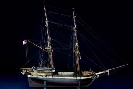
Ship Model of USS Porpoise
One of six ships of the U.S. Exploring Expedition, the Porpoise sailed around the world between 1838 and 1842.
Credit: National Museum of American History, Smithsonian Institution

wilkes-map-routes-39088007592942.jpg

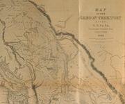
The Ex. Ex. Remaps the World
This map depicts their route and includes eyewitness accounts from crew members who had to navigate through unfamiliar seas and lands.
Credit: Smithsonian Institution Libraries

240-sil19-02-394.jpg

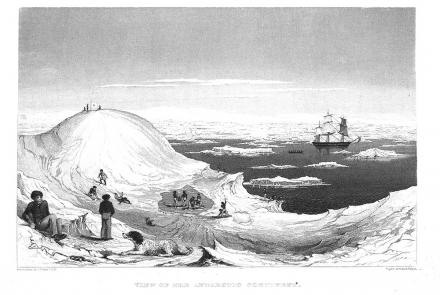
Playing on the ice, sketch by Charles Wilkes
A sketch by Charles Wilkes during the U.S. Exploring Expedition.
Credit: Smithsonian Institution Libraries
previous pauseresume next
  • Meet the Mapmaker: Charles Wilkes »

    Captain Charles Wilkes became known for his expertise and accuracy in mapping and charting.

  • Maps and Charts »

    In four years, the expedition effectively remapped the Pacific Ocean.

  • The "Scientifics" »

    The expedition also included a formidable group of botanists, naturalists, artists, taxidermists, and other scientists.

  • Navigating at Sea
    • Challenges of Sea Navigation
    • Navigating Without a Clock
    • The Longitude Problem
    • The U.S. Goes to Sea
      • Early Contributions
      • Wilkes Expedition
        • Meet the Mapmaker: Charles Wilkes
        • Maps and Charts
        • The "Scientifics"
    • Navigate at Sea! Activity
  • Navigating in the Air
    • Challenges of Air Navigation
    • Early Air Navigators
    • Navigation at War
    • Navigate the Skies! Activity
  • Navigating in Space
    • Challenges of Space Navigation
    • Reaching for the Moon
    • Navigating in Deep Space
    • Navigate in Space! Activity
  • Satellite Navigation
    • Challenges of Satellite Navigation
    • Reliable Global Navigation
    • Global Positioning System (GPS)
    • Who Uses Satellite Navigation
  • Navigation for Everyone
    • Meet a Professional Navigator
    • Personal Navigation Stories
  • Timeline of Innovation
  • Artifacts
  • Learning Resources
  • Multimedia Gallery
  • Research
  • Visit the Exhibition
  • Terms of Use
  • Privacy
  • Contact
  • Sponsors
  • Press
  • Donate
Smithsonian Logo National Air and Space Museum Home National Air and Space Museum Home National Museum of American History Home
Smithsonian
Home Facebook Twitter Google Plus Pinterest YouTube

This exhibition is a collaboration between the National Air and Space Museum and the National Museum of American History.

Sponsors | Contact | Terms of Use | Privacy