Smithsonian
  • Navigating
    at Sea
    • Challenges of Sea Navigation
    • Navigating Without a Clock
    • The Longitude Problem
    • The U.S. Goes to Sea
    • Navigate at Sea! Activity
  • Navigating
    in the Air
    • Challenges of Air Navigation
    • Early Air Navigators
    • Navigation at War
    • Navigate the Skies! Activity
  • Navigating
    in Space
    • Challenges of Space Navigation
    • Reaching for the Moon
    • Navigating in Deep Space
    • Navigate in Space! Activity
  • Satellite Navigation
    • Challenges of Satellite Navigation
    • Reliable Global Navigation
    • Global Positioning System (GPS)
    • Who Uses Satellite Navigation
  • Navigation
    for Everyone
    • Meet a Professional Navigator
    • Personal Navigation Stories
  • Timeline of Innovation
  • Artifacts
  • Learning Resources
  • Multimedia Gallery
  • Research
  • Visit the Exhibition

Search form

Time and Navigation Home
Facebook Twitter YouTube Pinterest
Time and Navigation
The untold story of getting from here to there.
Home

Search form

  • Navigating at Sea
  • Navigating in the Air
  • Navigating in Space
  • Satellite Navigation
  • Navigation for Everyone
  • Timeline of Innovation
  • Artifacts
  • Learning Resources
  • Multimedia Gallery
  • Research Journal
  • Visit the Exhibition
  • Challenges of Satellite Navigation
    • Navigation Gone Wrong: Soviets Shoot Down an Airliner
  • Reliable Global Navigation
    • Inertial Navigation
      • Charles Stark Draper
      • Developing Inertial Navigation
    • The First Satellite Navigation System
      • Transit Satellites
      • Navigating a Submarine
    • Improving Satellite Navigation
      • Clocks in Space
      • Evolving Solutions
  • Global Positioning System (GPS)
    • GPS Begins
    • The Satellite Constellation
    • Synchronized Accurate Time
    • Risks to the System
    • International Systems
  • Who Uses Satellite Navigation
    • Military Applications
    • Civilian Applications
      • The Commercial Market
      • Improving Accuracy
      • Looking Ahead

Explore More

ADS-B (Automatic Dependent Surveillance-Broadcast) »
Nortronics NAS-14V2 Astroinertial Navigation System »
Magellan GPS Advertisement »
Transit Receiver Mounted in a Vehicle in the Egyptian Desert »
GPS Modernization »

Reliable Global Navigation

The Cold War created new navigational challenges.

In a potential worldwide conflict, military response had to be immediate, accurate under all conditions, and reliable on any part of the globe. High-speed jet aircraft and ballistic missiles especially needed better mechanisms for navigation. Ground-based radio navigation techniques could be used, but satellite-based systems were developed to solve the problems of global navigation. Inertial navigation systems were developed and improved to provide guidance between fixes provided by celestial or radio navigation systems.

510-uss_alabama_-_dn-sc-85-07099.jpg

USS Alabama
The USS Alabama was outfitted with a SINS system for navigation.
Credit: U.S. Navy/General Dynamics Electric Boat

321-df-st-89-06284.jpg

Lockheed SR-71 Blackbird in Flight
Advances in computing made celestial navigation practical for the Mach 3+ SR-71.
Credit: U.S. Air Force; photo by Tech. Sgt. Michael Haggerty.

nasm2013-00299.jpg

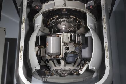
SINS Stable Platform and Housing Assembly
Information about the ship’s position, speed, heading, and attitude were constantly transmitted from the Ship's Inertial Navigation System (SINS).
Credit: National Air and Space Museum, Smithsonian Institution.
previous pauseresume next
  • Inertial Navigation »

    An Inertial Navigation System (INS) uses motion and rotation sensors along with a computer to figure out the position, orientation, and speed of movement.

  • The First Satellite Navigation System »

    Beeping radio signals from Sputnik inspired the idea of using satellites to navigate.

  • Improving Satellite Navigation »

    During the Cold War, U.S. defense planners sought a more accurate global navigation system.

  • Navigating at Sea
    • Challenges of Sea Navigation
    • Navigating Without a Clock
    • The Longitude Problem
    • The U.S. Goes to Sea
    • Navigate at Sea! Activity
  • Navigating in the Air
    • Challenges of Air Navigation
    • Early Air Navigators
    • Navigation at War
    • Navigate the Skies! Activity
  • Navigating in Space
    • Challenges of Space Navigation
    • Reaching for the Moon
    • Navigating in Deep Space
    • Navigate in Space! Activity
  • Satellite Navigation
    • Challenges of Satellite Navigation
    • Reliable Global Navigation
    • Global Positioning System (GPS)
    • Who Uses Satellite Navigation
  • Navigation for Everyone
    • Meet a Professional Navigator
    • Personal Navigation Stories
  • Timeline of Innovation
  • Artifacts
  • Learning Resources
  • Multimedia Gallery
  • Research
  • Visit the Exhibition
  • Terms of Use
  • Privacy
  • Contact
  • Sponsors
  • Press
  • Donate
Smithsonian Logo National Air and Space Museum Home National Air and Space Museum Home National Museum of American History Home
Smithsonian
Home Facebook Twitter Google Plus Pinterest YouTube

This exhibition is a collaboration between the National Air and Space Museum and the National Museum of American History.

Sponsors | Contact | Terms of Use | Privacy