Smithsonian
  • Navigating
    at Sea
    • Challenges of Sea Navigation
    • Navigating Without a Clock
    • The Longitude Problem
    • The U.S. Goes to Sea
    • Navigate at Sea! Activity
  • Navigating
    in the Air
    • Challenges of Air Navigation
    • Early Air Navigators
    • Navigation at War
    • Navigate the Skies! Activity
  • Navigating
    in Space
    • Challenges of Space Navigation
    • Reaching for the Moon
    • Navigating in Deep Space
    • Navigate in Space! Activity
  • Satellite Navigation
    • Challenges of Satellite Navigation
    • Reliable Global Navigation
    • Global Positioning System (GPS)
    • Who Uses Satellite Navigation
  • Navigation
    for Everyone
    • Meet a Professional Navigator
    • Personal Navigation Stories
  • Timeline of Innovation
  • Artifacts
  • Learning Resources
  • Multimedia Gallery
  • Research
  • Visit the Exhibition

Search form

Time and Navigation Home
Facebook Twitter YouTube Pinterest
Time and Navigation
The untold story of getting from here to there.
Home

Search form

  • Navigating at Sea
  • Navigating in the Air
  • Navigating in Space
  • Satellite Navigation
  • Navigation for Everyone
  • Timeline of Innovation
  • Artifacts
  • Learning Resources
  • Multimedia Gallery
  • Research Journal
  • Visit the Exhibition
  • Challenges of Air Navigation
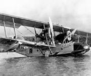
    • Flying Boats Cross the Seas
    • Overcoming the Challenges
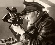
      • Celestial Navigation
      • Radio Navigation
      • Dead Reckoning
    • Navigate the Skies! Activity
  • Early Air Navigators
    • Dying to Set Records
    • Charles Lindbergh's Calculated Risk
    • The Business of Air Navigation
      • The Teacher: P. V. H. Weems
      • The Air Navigation Community
      • Radio Time for Aviation
    • Lindbergh's New Tools
    • Two Men in a Hurry
      • The Winnie Mae
      • Meet the Navigator: Harold Gatty
    • Navigation Gone Wrong: Amelia Earhart
  • Navigation at War
    • The Wartime Navigator
      • Harry Crosby
      • Tools of the Trade
    • Naval Aviation
      • Meet the Navigators: WAVES
    • A New Era in Time and Navigation
      • Hyperbolic Systems
      • LORAN
      • Meet the Clockmaker: Alfred Loomis
  • Navigate the Skies! Activity

Did You Know?

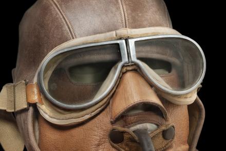
Early aviators’ helmets, masks, and goggles hint at the discomfort that made it so challenging to perform aerial celestial navigation. See what they were wearing.
Learn More »

Explore More

100th Bomb Group B-17s at Bomb Release »
APQ-7 Scope Image »
Radar Scope Image »
Pioneer Mark 3 Model 1 Aircraft Octant »
Radio Time Signals »

Challenges of Air Navigation

The hazards of aviation created a demand for specialized navigation and timing technology.

Early aviators on long flights sometimes faced great danger because they could not figure out exactly where they were. “Fixing” position over water, in the dark, or in poor weather was difficult. The consequences of getting lost could be dire. The celestial navigation tools sailors used at sea didn’t work as well in the air. Aviators needed new equipment and techniques. Why was navigating in the air more difficult than navigating at sea?

Speed

Airplanes moved many times faster than ships, so air navigators had to work faster to fix their position. Even minor miscalculations could result in much greater errors.

Instability

The natural roll of the airplane and air turbulence made taking accurate sightings and readings challenging.

Weather

Haze obscured the horizon line needed for sextant sightings. Clouds could keep navigators from sighting the Sun and stars or determining wind drift.

Cockpit Environment

Cramped open cockpits, low temperatures, and wind speeds over 160 kilometers (100 miles) per hour made air navigation unpleasant. Heavy gloves (or frozen fingers) made sighting with a sextant, determining drift, and making calculations nearly impossible.

  • Flying Boats Cross the Seas »

    Flying boats spearheaded aerial exploration and overseas transport in the 1920s and ’30s.

  • Overcoming the Challenges »

    Aviators have used three types of navigation in combination from World War I to the present day.

  • Navigate the Skies! Activity »

310-92-6534_small.jpg

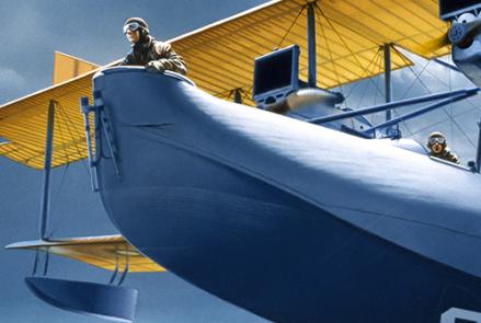
NC-4 by Ted Wilbur
The U.S. Navy’s Curtiss NC-4 flying boat made the first crossing of the Atlantic by air in 1919.
Credit: NC-4 by Ted Wilbur, Gift of Stuart M. Speiser, National Air and Space Museum, Smithsonian Institution.

nasm2012-02189.jpg

Interwar Flying Helmet and Mask
Aviation in the interwar years tested the limits of human endurance, making complex tasks like navigation highly problematic.
Credit: National Air and Space Museum, Smithsonian Institution.
previous pauseresume next
  • Navigating at Sea
    • Challenges of Sea Navigation
    • Navigating Without a Clock
    • The Longitude Problem
    • The U.S. Goes to Sea
    • Navigate at Sea! Activity
  • Navigating in the Air
    • Challenges of Air Navigation
      • Flying Boats Cross the Seas
      • Overcoming the Challenges
      • Navigate the Skies! Activity
    • Early Air Navigators
    • Navigation at War
    • Navigate the Skies! Activity
  • Navigating in Space
    • Challenges of Space Navigation
    • Reaching for the Moon
    • Navigating in Deep Space
    • Navigate in Space! Activity
  • Satellite Navigation
    • Challenges of Satellite Navigation
    • Reliable Global Navigation
    • Global Positioning System (GPS)
    • Who Uses Satellite Navigation
  • Navigation for Everyone
    • Meet a Professional Navigator
    • Personal Navigation Stories
  • Timeline of Innovation
  • Artifacts
  • Learning Resources
  • Multimedia Gallery
  • Research
  • Visit the Exhibition
  • Terms of Use
  • Privacy
  • Contact
  • Sponsors
  • Press
  • Donate
Smithsonian Logo National Air and Space Museum Home National Air and Space Museum Home National Museum of American History Home
Smithsonian
Home Facebook Twitter Google Plus Pinterest YouTube

This exhibition is a collaboration between the National Air and Space Museum and the National Museum of American History.

Sponsors | Contact | Terms of Use | Privacy