Smithsonian
  • Navigating
    at Sea
    • Challenges of Sea Navigation
    • Navigating Without a Clock
    • The Longitude Problem
    • The U.S. Goes to Sea
    • Navigate at Sea! Activity
  • Navigating
    in the Air
    • Challenges of Air Navigation
    • Early Air Navigators
    • Navigation at War
    • Navigate the Skies! Activity
  • Navigating
    in Space
    • Challenges of Space Navigation
    • Reaching for the Moon
    • Navigating in Deep Space
    • Navigate in Space! Activity
  • Satellite Navigation
    • Challenges of Satellite Navigation
    • Reliable Global Navigation
    • Global Positioning System (GPS)
    • Who Uses Satellite Navigation
  • Navigation
    for Everyone
    • Meet a Professional Navigator
    • Personal Navigation Stories
  • Timeline of Innovation
  • Artifacts
  • Learning Resources
  • Multimedia Gallery
  • Research
  • Visit the Exhibition

Search form

Time and Navigation Home
Facebook Twitter YouTube Pinterest
Time and Navigation
The untold story of getting from here to there.
Home

Search form

  • Navigating at Sea
  • Navigating in the Air
  • Navigating in Space
  • Satellite Navigation
  • Navigation for Everyone
  • Timeline of Innovation
  • Artifacts
  • Learning Resources
  • Multimedia Gallery
  • Research Journal
  • Visit the Exhibition
  • Challenges of Air Navigation
    • Flying Boats Cross the Seas
    • Overcoming the Challenges
      • Celestial Navigation
      • Radio Navigation
      • Dead Reckoning
    • Navigate the Skies! Activity
  • Early Air Navigators
    • Dying to Set Records
    • Charles Lindbergh's Calculated Risk
    • The Business of Air Navigation
      • The Teacher: P. V. H. Weems
      • The Air Navigation Community
      • Radio Time for Aviation
    • Lindbergh's New Tools
    • Two Men in a Hurry
      • The Winnie Mae
      • Meet the Navigator: Harold Gatty
    • Navigation Gone Wrong: Amelia Earhart
  • Navigation at War
    • The Wartime Navigator
      • Harry Crosby
      • Tools of the Trade
    • Naval Aviation
      • Meet the Navigators: WAVES
    • A New Era in Time and Navigation
      • Hyperbolic Systems
      • LORAN
      • Meet the Clockmaker: Alfred Loomis
  • Navigate the Skies! Activity

Did You Know?

“At a conservative estimate, 50 percent of the [aircraft] accidents in the last five years have been due to bad navigation.” —Sir Francis Chichester, British navigation authority, 1939

Explore More

Quartz Clock »
Mark IIB Pelorus Drift Sight »
Léon Challe, France »
Wolfgang von Gronau, Germany »
Anne Morrow Lindbergh »

Overcoming the Challenges

Aviators have used the same three basic types of navigation from World War I to the present day.

Dead reckoning is the simplest means of navigating but the least accurate over long distances. Radio navigation became the main method of navigation because of its precision and ease of use. Before global radio navigation systems, celestial navigation was preferred, but it is now only rarely used.

“Precise navigation of long-range aircraft requires careful coordination of all three methods of navigation: celestial for position fixes, dead reckoning for flight between the fixes, and radio direction finding for getting into the airport on the nose and for radio bearings when the sky is not visible.” – Harry Connor, navigator on Howard Hughes’ 1938 around-the-world flight

What Is Avigation?

Many air navigation pioneers wanted to distinguish themselves from sea navigators. One way they tried to do so was to call air navigation “avigation” and air navigators “avigators.” It did not catch on.

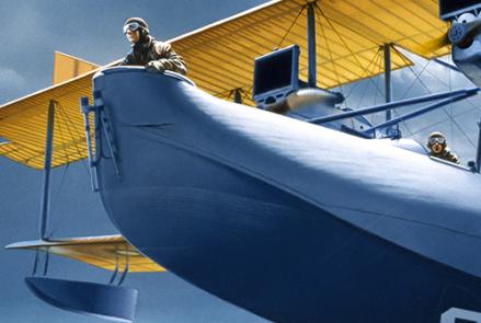
310-92-6534_small.jpg

NC-4 by Ted Wilbur
The U.S. Navy’s Curtiss NC-4 flying boat made the first crossing of the Atlantic by air in 1919.
Credit: NC-4 by Ted Wilbur, Gift of Stuart M. Speiser, National Air and Space Museum, Smithsonian Institution.

321-nasm-2a05865qm.jpg

Max Prüss, Graf Zeppelin Navigator
Using a sextant to find a Sun line of position.
Credit: National Air and Space Museum, Smithsonian Institution.
previous pauseresume next
  • Celestial Navigation »

    Celestial navigation required a clear view of the sky and different tools than those used at sea.

  • Radio Navigation »

    Radio navigation became the most important air navigation technology.

  • Dead Reckoning »

    Air navigation depended on best guesses of position made between visual, radio, or celestial fixes.

  • Navigating at Sea
    • Challenges of Sea Navigation
    • Navigating Without a Clock
    • The Longitude Problem
    • The U.S. Goes to Sea
    • Navigate at Sea! Activity
  • Navigating in the Air
    • Challenges of Air Navigation
      • Flying Boats Cross the Seas
      • Overcoming the Challenges
        • Celestial Navigation
        • Radio Navigation
        • Dead Reckoning
      • Navigate the Skies! Activity
    • Early Air Navigators
    • Navigation at War
    • Navigate the Skies! Activity
  • Navigating in Space
    • Challenges of Space Navigation
    • Reaching for the Moon
    • Navigating in Deep Space
    • Navigate in Space! Activity
  • Satellite Navigation
    • Challenges of Satellite Navigation
    • Reliable Global Navigation
    • Global Positioning System (GPS)
    • Who Uses Satellite Navigation
  • Navigation for Everyone
    • Meet a Professional Navigator
    • Personal Navigation Stories
  • Timeline of Innovation
  • Artifacts
  • Learning Resources
  • Multimedia Gallery
  • Research
  • Visit the Exhibition
  • Terms of Use
  • Privacy
  • Contact
  • Sponsors
  • Press
  • Donate
Smithsonian Logo National Air and Space Museum Home National Air and Space Museum Home National Museum of American History Home
Smithsonian
Home Facebook Twitter Google Plus Pinterest YouTube

This exhibition is a collaboration between the National Air and Space Museum and the National Museum of American History.

Sponsors | Contact | Terms of Use | Privacy