Smithsonian
  • Navigating
    at Sea
    • Challenges of Sea Navigation
    • Navigating Without a Clock
    • The Longitude Problem
    • The U.S. Goes to Sea
    • Navigate at Sea! Activity
  • Navigating
    in the Air
    • Challenges of Air Navigation
    • Early Air Navigators
    • Navigation at War
    • Navigate the Skies! Activity
  • Navigating
    in Space
    • Challenges of Space Navigation
    • Reaching for the Moon
    • Navigating in Deep Space
    • Navigate in Space! Activity
  • Satellite Navigation
    • Challenges of Satellite Navigation
    • Reliable Global Navigation
    • Global Positioning System (GPS)
    • Who Uses Satellite Navigation
  • Navigation
    for Everyone
    • Meet a Professional Navigator
    • Personal Navigation Stories
  • Timeline of Innovation
  • Artifacts
  • Learning Resources
  • Multimedia Gallery
  • Research
  • Visit the Exhibition

Search form

Time and Navigation Home
Facebook Twitter YouTube Pinterest
Time and Navigation
The untold story of getting from here to there.
Home

Search form

  • Navigating at Sea
  • Navigating in the Air
  • Navigating in Space
  • Satellite Navigation
  • Navigation for Everyone
  • Timeline of Innovation
  • Artifacts
  • Learning Resources
  • Multimedia Gallery
  • Research Journal
  • Visit the Exhibition
  • Challenges of Air Navigation
    • Flying Boats Cross the Seas
    • Overcoming the Challenges
      • Celestial Navigation
      • Radio Navigation
      • Dead Reckoning
    • Navigate the Skies! Activity
  • Early Air Navigators
    • Dying to Set Records
    • Charles Lindbergh's Calculated Risk
    • The Business of Air Navigation
      • The Teacher: P. V. H. Weems
      • The Air Navigation Community
      • Radio Time for Aviation
    • Lindbergh's New Tools
    • Two Men in a Hurry
      • The Winnie Mae
      • Meet the Navigator: Harold Gatty
    • Navigation Gone Wrong: Amelia Earhart
  • Navigation at War
    • The Wartime Navigator
      • Harry Crosby
      • Tools of the Trade
    • Naval Aviation
      • Meet the Navigators: WAVES
    • A New Era in Time and Navigation
      • Hyperbolic Systems
      • LORAN
      • Meet the Clockmaker: Alfred Loomis
  • Navigate the Skies! Activity

Did You Know?

“Eskimos found a block of ice yesterday with seven frozen sheep in it. They are busy now chopping them out and distributing the meat. Just another sign of the past tough winter." — In a letter from Coast Guardsman Samuel Michaels describing conditions at the first overseas LORAN station in Greenland on May 30, 1943
Learn More »

Explore More

Arthur Goebel, William Davis Jr., Martin Jensen, and Paul Schluter »
Captain Letterio Cannistracci, Italy »
J.P. Saul, Ireland »
Harry H. Crosby's Navigation School Certificate »
Gee Chart, Reims Chain, December 1944, 1/1000000 scale »

Why Was LORAN Such a Milestone?

With LORAN, navigators went from using mechanical-based time measured in seconds to using radio frequency-based time measured in microseconds (millionths of a second).

Mechanical clocks and watches that referenced a standardized time became less important to navigation, because electronic systems such as LORAN could accurately calculate a relative position with their own internal time.

This achievement was only possible through massive national investments in developing and combining the technologies of radio transmission and timing.

LORAN’s heart was its timing unit—a crystal oscillator that allowed a receiver on an aircraft, ship, or submarine to measure the difference between “master” and “slave” radio pulses. Early LORAN equipment was sensitive, and operators had to monitor it carefully, especially in areas with salt air and high humidity, which rapidly corroded components.

Many LORAN stations were in remote, inhospitable places. They required extensive infrastructure—personnel quarters, water and fuel tanks, communications equipment, and electrical generators—such as the one in Adak, Alaska. Duty here was dull and tedious, but also relatively safe compared with many types of wartime service.

By the end of World War II, LORAN chains consisting of 72 operable stations provided navigation over 30 percent of the globe, mostly in the northern hemisphere. More than 70,000 receivers for aircraft, ships, and submarines had been built. By the height of the Cold War, coverage had extended to 70 percent of the Earth’s surface. The ionosphere and terrain limited daytime coverage, so LORAN was far more effective at night.

nasm2012-02140.jpg

AN/APN-4 LORAN Set
The first LORAN receiver for aircraft use to enter service.
Credit: National Air and Space Museum, Smithsonian Institution

How LORAN Works

How LORAN Works
Length: 2 Minutes, 1 Second
Credit: National Air and Space Museum, Smithsonian Institution

loran_map_2.jpg

LORAN Day and Night Coverage, 1945
By the end of World War II, the LORAN system could be used over 30 percent of the globe.
Credit: National Air and Space Museum, Smithsonian Institution.

History of the LORAN System

History of the LORAN System
Length: 2 Minutes, 17 Seconds
Credit: National Air and Space Museum, Smithsonian Institution.

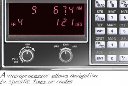
300-si_loran_c_fa_flat_11-1-12b.jpg

LORAN-C (LOng RAnge Navigation)
Aircraft equipment interprets time delays from pairs of ground stations.
Credit: National Air and Space Museum, Smithsonian Institution.

211852.jpg

LORAN Station, Adak, Alaska
The typically austere conditions present at many remote LORAN stations during World War II.
Credit: National Archives and Records Administration
previous pauseresume next
  • Navigating at Sea
    • Challenges of Sea Navigation
    • Navigating Without a Clock
    • The Longitude Problem
    • The U.S. Goes to Sea
    • Navigate at Sea! Activity
  • Navigating in the Air
    • Challenges of Air Navigation
    • Early Air Navigators
    • Navigation at War
      • The Wartime Navigator
      • Naval Aviation
      • A New Era in Time and Navigation
        • Hyperbolic Systems
        • LORAN
        • Meet the Clockmaker: Alfred Loomis
    • Navigate the Skies! Activity
  • Navigating in Space
    • Challenges of Space Navigation
    • Reaching for the Moon
    • Navigating in Deep Space
    • Navigate in Space! Activity
  • Satellite Navigation
    • Challenges of Satellite Navigation
    • Reliable Global Navigation
    • Global Positioning System (GPS)
    • Who Uses Satellite Navigation
  • Navigation for Everyone
    • Meet a Professional Navigator
    • Personal Navigation Stories
  • Timeline of Innovation
  • Artifacts
  • Learning Resources
  • Multimedia Gallery
  • Research
  • Visit the Exhibition
  • Terms of Use
  • Privacy
  • Contact
  • Sponsors
  • Press
  • Donate
Smithsonian Logo National Air and Space Museum Home National Air and Space Museum Home National Museum of American History Home
Smithsonian
Home Facebook Twitter Google Plus Pinterest YouTube

This exhibition is a collaboration between the National Air and Space Museum and the National Museum of American History.

Sponsors | Contact | Terms of Use | Privacy